
Off the Beaten Track 17 – Pinhoulland
Published: 22 July 2020
Plantiecrubs with a secret
It is almost impossible to go for a walk in Shetland without seeing a plantiecrub (krub), the small enclosures in the hill for kale seedlings. However it is worth looking more closely. Plantiecrubs were usually built where there was a good supply of stone. Unfortunately archaeological sites, especially early prehistoric ones, were perfect and even included large upright stones (orthostats) - a short-cut for crofters. The clues to look for include curves of stone poking out from beneath the krub, a greener grassy area outside the crub, and large upright stones in the krub wall. Today’s West Side walk will take in some reused sites.
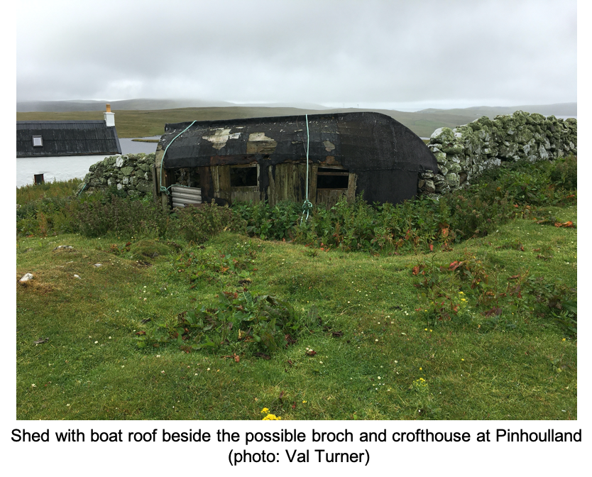
Heading towards Walls from the Bridge of Walls, leave the road on the metalled track to the left signposted “Historic Site” (HU 248 499), about 600 metres before you enter Walls. There is public parking just before the cattle grid. Enter the gate on the left, before the farm to find a possible broch (HU 255 498) behind the modern steading.
The stonework consists of huge lumps of undressed (unworked) rock - far cruder than the stone usually found in brochs. However, brochs were always made of the local stone, and this stone did not split easily. The fact that only large stones survive in the foundations might be explained by looking around you. There are an extraordinary number of full-height drystone dykes in the immediate vicinity. The broch was probably used as a quarry.
On the far side of the broch is a fine example of a shed with an upturned boat roof. The shape and size of the boat dictated the dimensions of the shed, so boat roofs tended to be reserved for henhouses and lamb sheds (lambhus).
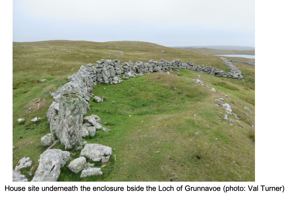
Return to the track, crossing into the field on the other side and head towards a gap in the wall ahead. Go through the next gate and head towards the green area beside the Loch of Grunnavoe (HU 258 494).
On top of the green mound is a 19th century enclosure, but inside there are one, or possibly two, prehistoric house sites. The western one is the better preserved and has a stony bank 0.7 metres high.
There are traces of a third house site beneath the nearby plantiecrub. At least four associated small fields survive as banks and enclosures, having a few small clearance cairns scattered amongst them. A clearance cairn is a heap of stones which were either ploughed or dug up during cultivation. Curiously there can be so many of them on some sites that they appear to create obstacles for the early farmer.
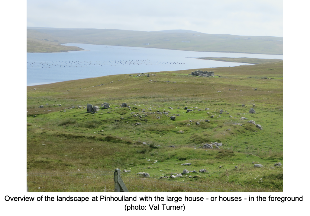
Turn your back on the loch, heading north. Within 200 - 300 metres you will meet a long continuous stony bank, a well-preserved prehistoric land division between settlements. Follow this to the ridge to arrive at the southern end of the most extensive and complex (currently known) prehistoric settlement in Shetland.
Pinhoulland – an exceptional site? (centred on HU 259 499)
The first monuments you encounter are three mounds, one at the highest point on the ridge. The other two lie just below the slope immediately to the east. All three resemble sub-rectangular chambered (burial) cairns. Admittedly, it would be extremely unusual to find three chambered cairns together, but there are two cairns (of differing types) in close proximity on Pettigarth’s Field, Whalsay (ST 26 June). It is also unusual, but not unprecedented, to find a burial cairn quite so close to an early prehistoric farming settlement. Excavations near South Nesting Hall revealed a chambered cairn at the edge of field, not far from a prehistoric house. There was also a ring cairn at the Scord of Brouster, built after the settlement was abandoned. Clearly we need more excavation – and this would be a prime site if sufficient funding were ever available to tackle it properly.
There are three detailed archaeological surveys of this site, including my own. Every archaeologist who has ever visited it has interpreted the components differently. That is not surprising as, without excavation, it is impossible to identify some of the enigmatic mounds with certainty.
Today the land doesn’t look as if it would support more than a few sheep, but this was once a thriving settlement of eight fields and eight or more prehistoric house sites. These sites are usually dated vaguely as Neolithic to Bronze Age. It is unlikely that all the houses were in use at once. This was probably a farm which survived for centuries, new houses replacing older ones and more land being taken into cultivation over time. To confuse the issue further, recent excavations at Troni Shun, just a few miles away, turned out to be a Neolithic house which was remodelled and re-inhabited in during Pictish times – perhaps as much as 3,000 years later.
When I carried out micromorphology – examining a slice of the soil under a microscope – I could see that the original land-surface supported a healthy “brown soil”. The first settlers almost certainly grew barley before the peat began to form. Like Neolithic and Bonze Age people elsewhere in Shetland, they may have added domestic waste to the soil, but they did not manage it intensively enough to keep it fertile indefinitely.
There are eight convincing Neolithic/Bronze Age houses in the settlement. They all have internal stonework, but they vary considerably in size and degree of preservation. Ditlev Mahler’s survey counted 17. See how many you think there are.
One point of divergence between my interpretation and Mahler’s was the huge mound at the north end of the site, measuring approximately 16 metres by 12 metres, sitting within its own enclosure. I counted it as a single house whereas Mahler divided it into six. If there were several houses packed together here, this would be exceptional. Although Mahler drew parallels with Jarlshof, the proposed Pinhoulland houses would have to be much smaller and more densely packed in order to fit within the mound if they were contemporary. But perhaps the mound was used repeatedly over a lengthy period? Only excavation will solve the puzzle.
One of the prehistoric houses is hidden under a disused plantiecrub. The krub is exceptionally irregular - perhaps due to the underlying house. The krub incorporates two orthostats from the house into its walls. The plantiecrub shows that, while the area was not cultivated in the post-medieval/modern period, it was still part of the croft.
There are at least two houses which seem to have two, roughly circular, components. One of these is just below the southern ridge. The larger area in each was probably domestic and, if they follow the same pattern as the excavated site at the Scord of Brouster, the smaller area was a workshop.
Two of the fields, closer to the voe, may not have been attached to the main settlement. The most recent constructions on the site are also found beside the voe - a boat noost, a duck house and a ruinous sheep pen.
Once you have explored the site and counted the houses, the most straightforward way of returning is to use the gates which you arrived by. There are alternative routes back and the modern settlement to head for is in view much of the time, but you need to be willing to climb fences or gates to do that.
Dr Val Turner, Regional Archaeologist, July 2020
We hope you have enjoyed this blog.  We rely on the generous support of our funders and supporters to continue our work on behalf of Shetland. Everything we do is about caring for Shetland's outstanding natural and cultural heritage on behalf of the community and for future generations. Donations are welcomed and are essential to our work.