
Off the Beaten Track 16 - Eastshore, South Voe
Published: 15 July 2020
Shetland’s South Mainland has one of the greatest densities of broch sites anywhere. Jarlshof and Old Scatness are key visitor sites in the South Mainland chain, but this walk visits three lesser-known brochs. If you’d like to add a fourth, why not buy your snacks for the walk at Toab shop? In the field opposite are the earthwork remains of the Broch of Toab, unknown until the late 1990s Amenity Trust survey.
This linear walk follows the coastal core path. It is close to the cliff edge in places, so not advisable in a strong westerly wind. If you have two vehicles, leave one by the Crofthouse Museum. For spectacular views, walk south to north.
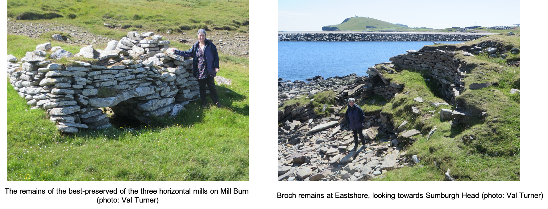
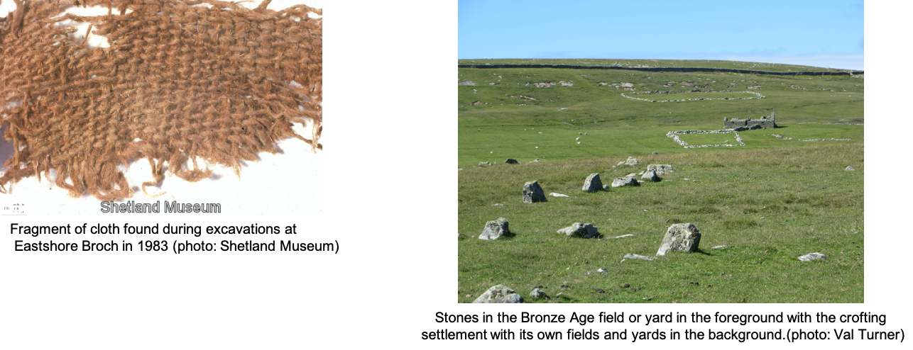
Start at Dunrossness Boating Club using the gate beside it. Part of Eastshore Broch (HU 403 113) has been lost to the sea, but the half which remains is over 3 metres high and is currently stable. The scarcement – a ledge which helped to support an upper wooden floor –survives around the best-preserved inner face of the broch wall. The inside of the broch was remodelled in the later Iron Age. The eroding edge was excavated in 1983 and, like Jarlshof, includes Neolithic, medieval and more recent crofting buildings. The most remarkable find was a preserved piece of woven cloth.
Eastshore became the site of a fishing station which included an ice house. Ice was collected from a lochan behind the beach and used to pack the fish. Fish were also laid out on the beach here to dry. One of the last buildings to be occupied, known as “The Broch Ebb”, was home to an elderly lady who had to be rescued from it during a gale in 1900.
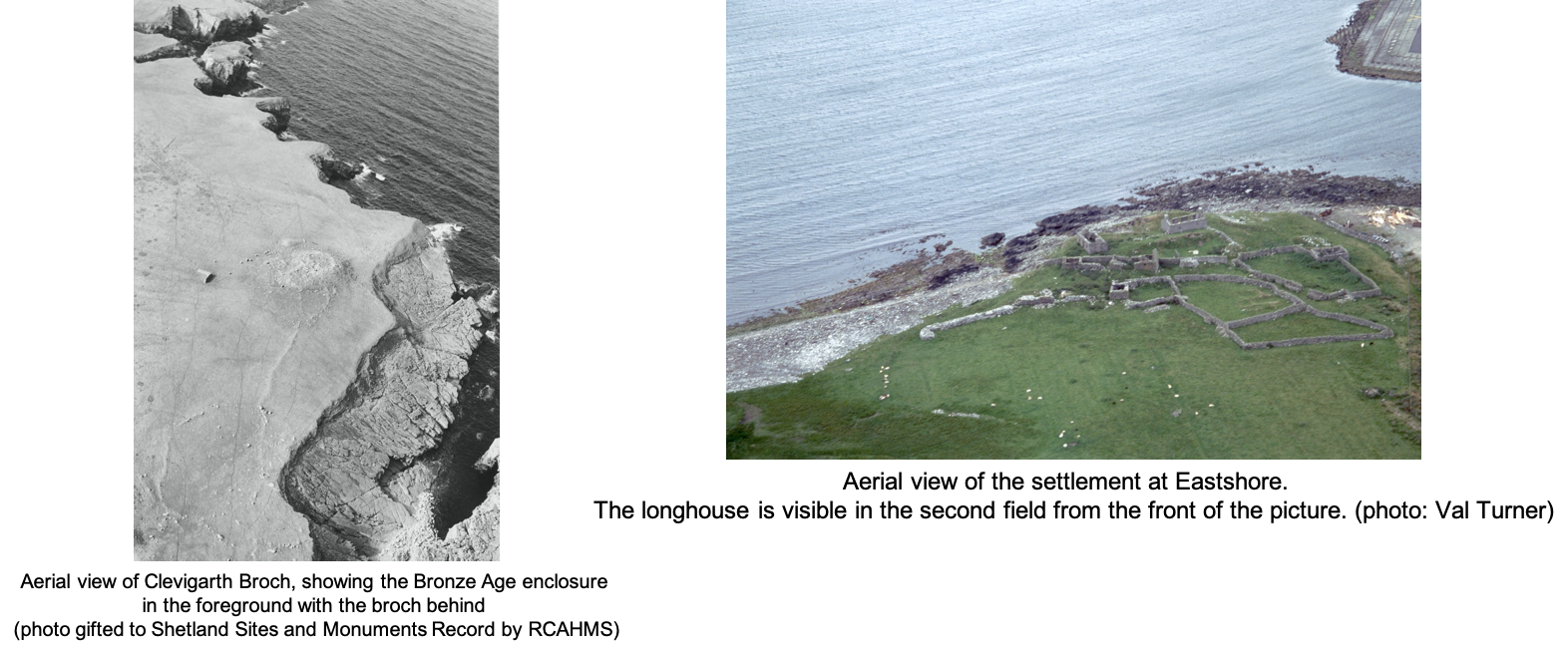
Eastshore Longhouse (HU 402 113)
The longhouse at Eastshore is difficult to see at the moment because the grass is so long. When the grass is short it is easy to see, with well-defined, turf-covered stone walls, standing 0.5 metres high. To find it, head inland a few metres from the broch, between two buildings and bear left. Pass through a gap between two fields then turn right, following the wall. Enter into a small field. The longhouse is on the side closest to the boating club. It has a side room attached to its southern long-wall. The surrounding wiggly stone dyke stands between 1-1.3m high. Its uneven nature hints that it may have originated as a Norse yard-dyke.
From Eastshore, head across the field, crossing the road beside a layby. Follow the coastal walk markers over a stile and through a gap in the wall to your right and cross the field to a gate beside a dry-stone yard. Beyond the yard there are two small burnt mounds (ST 22 May) beside a, currently dry, shallow lochan (HU 404 118). Fire-reddened stones peep through the grass along with a few slabs from the central water trough.
Continue north, passing through a gate. From here you can see the broch of Clevigarth on the horizon, above a rock point. The route passes many rectangular plantiecrubs. The majority of plantiecrubs (shelters for kale seedlings) in Shetland are circular, but there are regional variations. The rectangular shape might reflect the local availability of good building stone in Dunrossness.
The burn flowing into Millburn Geo boasts three horizontal mills (HU 405 122). The under-houses all survive. Water flowed through these to turn the paddle (ST 3 July). The central one is best preserved, retaining several courses of the superstructure.
From here, the coastal path stile leads onto the cliff-top above Shingly Geo - please take care. 380 million years ago the banded rocks at the bottom of the geo were at the bottom of a lake. It was home to a strange and primitive, plate-skinned, fish. Today the rocks contain their fossils.
Leave the cliff edge, entering a field full of stone. Many have been thrown up to their present positions by the incredible power of the sea. However, once you pass the gate into the next field, you will begin to notice lines of stones which were once field boundaries. Looking at the crofting settlement on the hill to the left, the fields and a more distant yard are obvious. The curving boundary in front of you, beside the cliff top, is the Bronze Age equivalent of a yard which is 3000 years old. There is a larger field beside it and two parallel lines of stone lead from here to the north-west, perhaps a drove-way for cattle. There is a boundary leading towards the broch and another on the far side of the broch. This could be the first Shetland discovery of a complex field system apparently associated with a broch.
Looking again at the far hillside, but further south, spot the modern Ratchie Quarry, the source of the flat stone favoured by today’s dry-stone workers. It could once have been the quarry for the South Mainland broch stone.
The broch of Clevigarth stands at the highest point of the relatively flat cliff-top (HU 407 129). It is protected on the seaward side by The Cletts, a ridge of rock running parallel to the land on the far side of Blo Geo. The broch survives as a mound of turf and stone, about 19 metres diameter and 3-4 metres high. There are traces of the inner and outer walls, and suggestions of outbuildings at its foot. Soil survey identified an early prehistoric phase of cultivation when midden was added to the soils to grow crops.
Continue north over a ladder and then a stile. Look out for an area of red iron stained rocks and iron pan. Water causes iron to leach out of the peat and creates a layer of iron where it encounters something solid, which stops it moving any further. This iron pan, or bog iron, was smelted for the iron which defined the Iron Age.
Another ladder takes you into the field of the Lambhoga Head or Lambigert promontory (HU 408 139). A modern dyke overlies an earlier bank. There are several depressions inside the most obvious of which (north) is the right size for a chapel, if this was a monastic promontory. It has also been recorded as a fort. Its name suggests that it was walled off for animal husbandry, but this could reflect post-Iron Age reuse.
Lambigert was the scene of a huge rock fall in the 1970s with stones also being thrown onto the land above. A loud noise heard about then led to local speculation about this being caused by an exploding mine.
As you head north you will encounter a sinuous dyke, then a small waterfall and off-shore stack, before the next stile. After carefully passing a large geo, another stile, a tumbled wall, and two more ladders you will arrive at South Voe Broch. As you travel, Dalsetter Broch stands out clearly on the opposite side of the voe.
Southvoe Broch (HU 340 147)
The broch mound is about 20m wide and covered in long grass. It is highest on the seaward side. Spot the traces of the inner broch wall on the west side and 2 lintels on the south side. To the southwest are traces of other buildings, perhaps Iron Age roundhouses.
From the broch, return south to join the hardcore path. It leads past the restored horizontal mill and the Crofthouse Museum – a good place to finish your walk.
Dr Val Turner, Regional Archaeologist, July 2020
We hope you have enjoyed this blog.  We rely on the generous support of our funders and supporters to continue our work on behalf of Shetland. Everything we do is about caring for Shetland's outstanding natural and cultural heritage on behalf of the community and for future generations. Donations are welcomed and are essential to our work.