
Off the Beaten Track 13 - Whalsay
Published: 26 June 2020
 In writing articles about archaeology for the Shetland Times I am following in the august footsteps of John Stewart. He wrote a chronological narrative for the paper in 1956, later published as an “Outline of Shetland Archaeology”. Charles Calder had begun recording Shetland’s archaeology in the1930s, but work was severely curtailed by the outbreak of war. It was hastily finished in 1948. Stewart, a teacher in Aberdeen who returned home to Whalsay in the summers, was inspired to excavate on Pettigarth’s Field. When Calder returned to Shetland he helped Stewart to finish the work and to begin to redress some of the gaps he had left in recording Shetland’s archaeology. The two became a formidable team and started the task of putting Shetland on the map for its wonderful prehistoric archaeology. Today I invite you explore some of their work in Whalsay.
Isbister to Pettigarth’s Field
 This is a walk which I have usually approached from Lochend, Isbister (HU 579 644), although it is equally possible to start either at the airstrip at Skaw (HU 593 666) or the disused quarry at Muckle Breck (HU 587 660). There are also options for an out and back walk, focused on Pettigarth’s Field, or you can add in more sites for a longer walk. These directions are for the longer version.
Take the track towards Alma and then head east, towards the coast. A Neolithic oval house, known as “The Gairdie” (HU 585 646) sits on a slope close to a plantiecrub. It was partially excavated by Charles Calder in the 1950s. He described the inner end as being “apsidal”, comparing it to the semicircular recess often found at the end of a church. You can spot traces of the surrounding enclosure to the south of the house.
Although this is an archaeological walk, do take a look at the natural arch about 100 metres to the north-east at Gloupa. Heading north towards Longi Geo, you will cross the remains of a long bank with an enclosureby the geo.
An optional detour to the highest point between the Loch of Isbister and West Loch of Skaw brings you to Willie’s Wart (HU 582 652) and the remains of a cairn which surrounded a cist (stone slab box). Stewart removed most of the cairn stones, although some of the kerb stones are still in place. He found a hammer stone and a flint flake in the cist.
Stewart and Calder’s Highlights
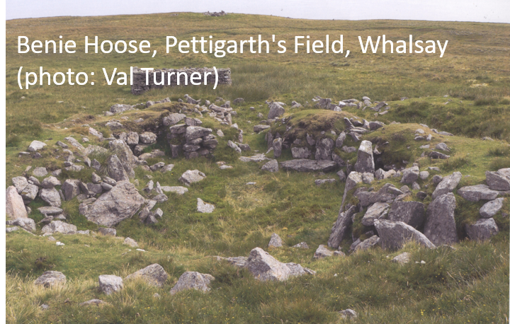 The archaeological sites on Pettigarth’s Field are some of Shetland’s must-see sites and if you are short of time then head straight for these. The two Neolithic/Bronze Age houses were left open after being excavated, which makes them much easier to understand than examples covered with vegetation. (The rectangular pile of stones close to the Benie Hoose is stone removed during the excavations, including from a plantiecrub which had been built on top of it.) Both houses are aligned down the slope, with their entrances facing the sea. Both have alcoves around a central hearth and long entrance passages which led into the outer courtyard, which may or may not have been roofed and may have been workshop areas or pens for young animals.
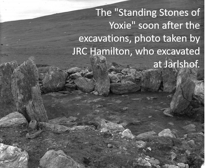 The most coastal of these is just above Yoxie Geo. Before the excavation of “The Standing Stones of Yoxie” (HU 587 652) people claimed that it must be a temple. This was because the pointed tips of the huge orthostats (large stones standing on end, found at key points in the walls) were all that could be seen before excavation began. The house has a large porch protecting the entrance.
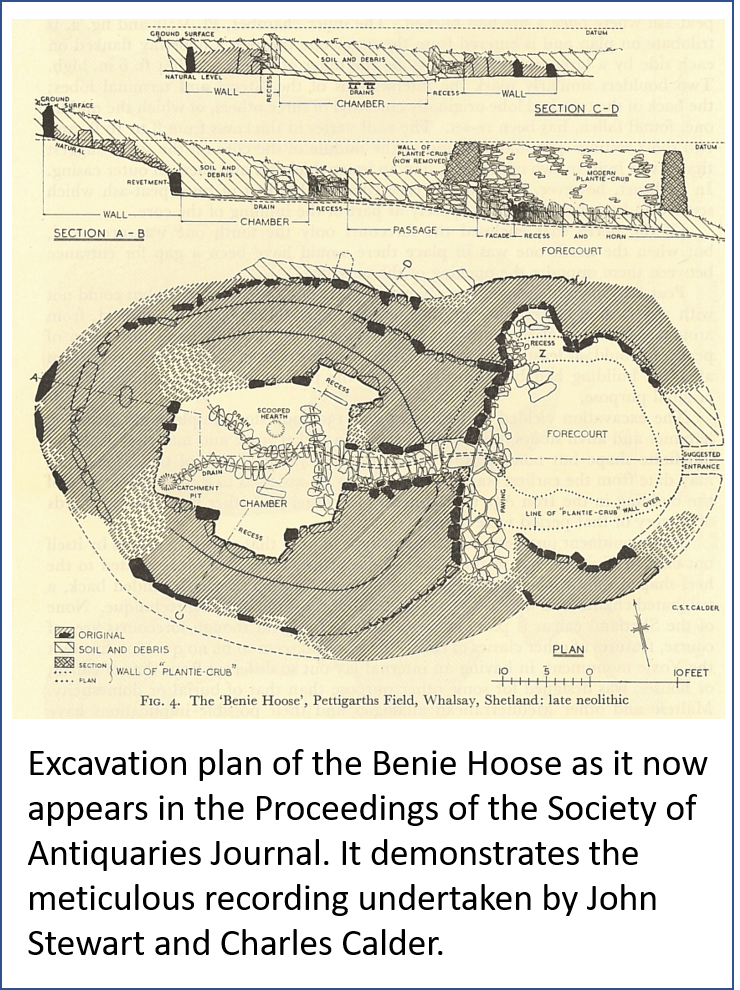
The “Benie” or “Bunyie” Hoose (HU 586 652) is about 200 metres inland. Calder thought that its name derived from the Old Norse “Boenhus” or “house of prayer” and it became known as the “Priest’s house”. However, it turned out to be an exceedingly well built example of a Neolithic or Bronze Age house. The walls and interior of the Benie Hoose contained an enormous number of hammerstones, pounders, stone discs, querns, and other stone tools – more than 1,800 artefacts in total.
Stewart had begun to excavate the site before he met Calder and their published results set new standards in recording. Their drawing showed faces of walls within the wall thickness. Whether or not they understood what they were looking at, their drawings show the several phases of adding midden (domestic waste) around the walls and then facing it, showing that the house became better insulated over time. The many stone tools included in the waste and the two rebuilding phases suggest that the house was in use for an extremely long time.
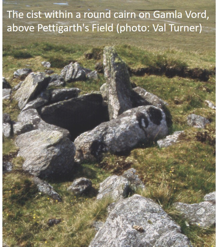
The houses were set amongst fields and clearance cairns, but there is a chambered cairn (for burial) overlooking the settlement, higher up Gamla Vord (HU 585 653). Originally the tomb was covered with a square cairn. The entrance, a narrow passage, ends at a small oval chamber. This has a clover leaf layout of three burial recesses, divided from one another by large stone slabs protruding from the walls.
On the north side of the chambered cairn is a later round cairn, which covered a large cist built with four massive slabs. The slab which originally covered the cist has, at some point, slipped into it. The burials were both disturbed before prior to excavation and none of the contents survived. The two tombs were not contemporary with each other, but there are no precise dates for either and archaeologists can only guess at how they were used.
To continue the walk, head for the east side of the airstrip to discover a burnt mound beside the East Loch of Skaw (HU 593 666). A plantiecrub has been built on top of it.
Join the road and head south. There are three standing stones (HU 588 663) in the field on the opposite (west) side of the road metres to Treebs. 'The Stone of the Toon' is about 50 metres from the shore and is 1.5 metres high and about twice that in girth. The second has been broken and now only stands around 0.3 metres high. The stone to the west, about 1.4 metres long, is recumbent (on its side). It is similar to the other and probably also once stood upright.
Follow the coast to another burnt mound (HU 587 663).
Continue west, along the coast, and head for a plantiecrub (HU 582 665). Plantiecrubs often hide earlier remains because the crub-builders realised that they were a good source of stone. The clues to look for are greener patches outside part of the crub wall or, as in this case, a curving length of bank or dyke. This house site survives as an oval hollow inside a bank which was around 1.5 metres thick. There is a more enigmatic building about 50 metres to the north.
Follow the coast west to the slipway, and then take the track back to the road. Cross the road and perhaps set off along the track around the West Loch of Skaw, breaking off to head due south for 1km, until you reach more tracks which take you back to Alma, Lochend and Isbister.
Dr. Val Turner, Regional Archaeologist, Shetland Amenity Trust
We hope you have enjoyed this blog.  We rely on the generous support of our funders and supporters to continue our work on behalf of Shetland. Everything we do is about caring for Shetland's outstanding natural and cultural heritage on behalf of the community and for future generations. Donations are welcomed and are essential to our work.