
Place Name of the Week - Noosts
Published: 03 September 2020
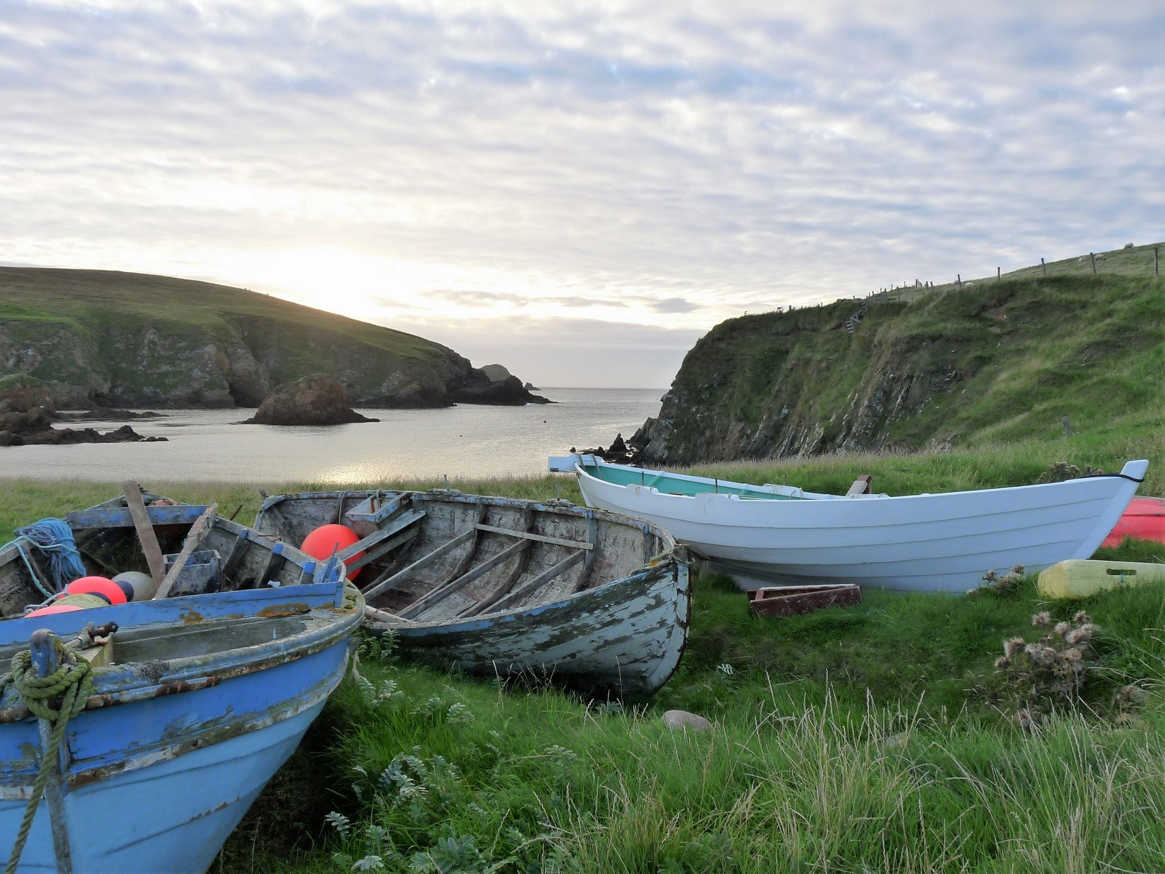
Noosts, nousts or nowsts, are places where boats are drawn up from the sea. They occur along the coastline of Northern and Western Scotland and Scandinavia and take their name from the Old Norse naust meaning a boatshed. This same word is used in modern Norwegian and Danish.
Noosts were specially prepared hollows in the grass above the high tide mark, often lined with large flat stones to help protect the boats. Some crofts had a noost at their foreshore, but otherwise they were grouped together at safe landing places. There were often both summer and winter noosts, the latter being more secure and a bit further away from the sea. The term also applies to the landing place between rocks or shingle. Rocks were broken up and removed to make a clear channel, and fires were sometimes lit to help split the larger rocks. In other instances, stones were built out to form shallow piers.
Spiggie
Most noosts are named after the croft to which they belonged, for example Avensgarth, Gruna, Brunatwatt and Tua Noosts. Some names relate to nearby fishing stations, whilst others carry the names of individuals who used them, such as Rasmie, Cleekie, Robertson, Sandy and Runk. These were often great characters, but too often the detail has been forgotten. One such person lived at the Cunningsburgh Wast Banks and gave his name to Spencie’s Toon, Spencie’s Gaet and Spencie’s Noost. Spencie reputedly had extraordinary eyesight, often giving detailed accounts of activities on the land to his fellow fishing crew whilst still far out to sea. He also was known to be incredibly mean to his wife, whom he eventually murdered. Following imprisonment in the Tolbooth, Spencie broke free, stole a Ness yoal from a noost at Sound and sailed single-handed to mainland Scotland!
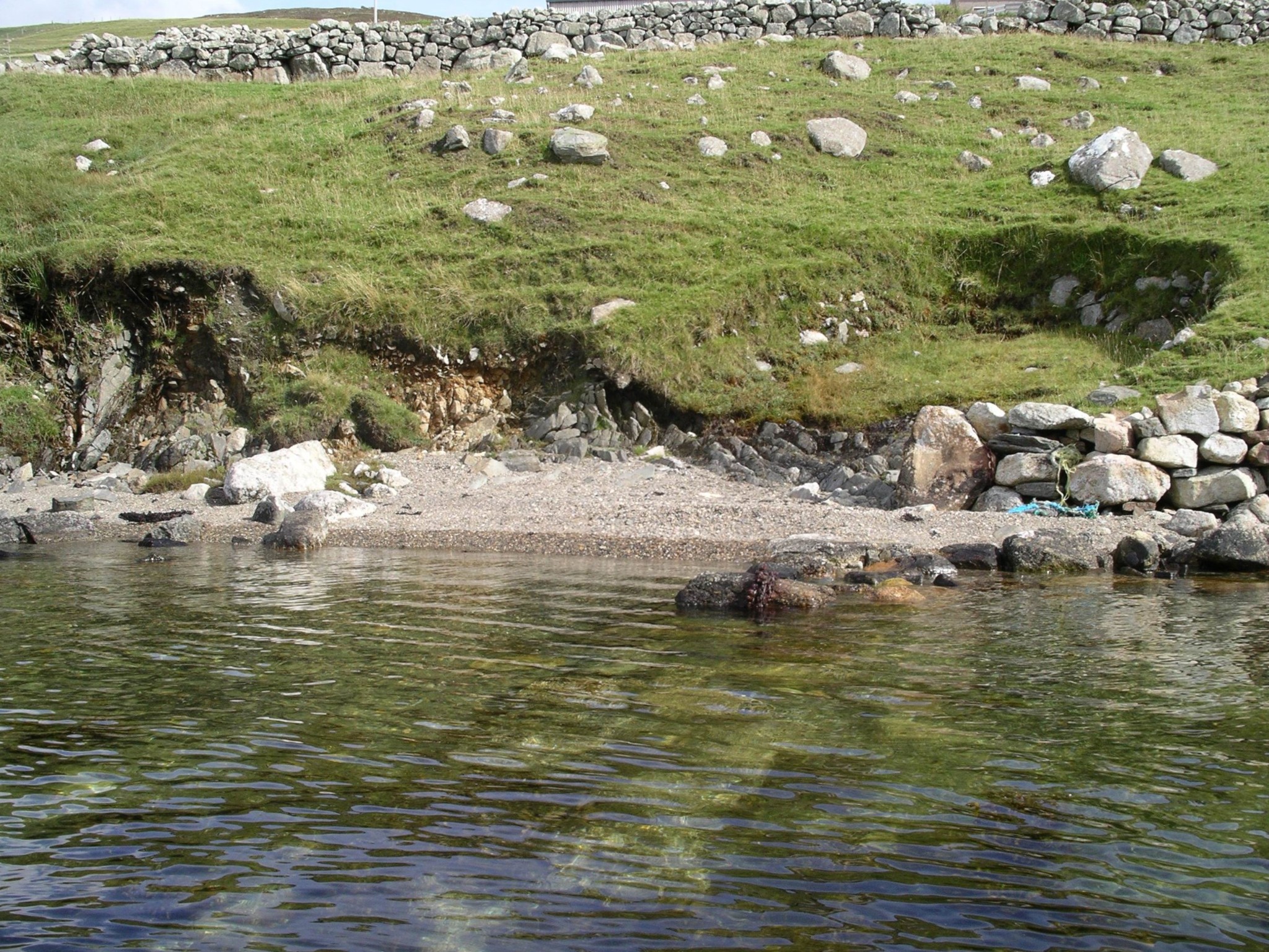
Although many noosts are still in use, others have become overgrown and can only be traced by walking the ground and talking to local folk. Very few of them have been plotted on official maps. Sometimes nearby place-names like Noustal, Nista Skerries and Nistataing suggest their whereabouts. Other noosts such as Starnie’s Hol, Aglam and The Gill are not obvious from their names and could easily be overlooked.
.jpg)
.jpg)
We have plotted many noosts as part of our work recording Shetland place-names and new projects run by Moder Dy is taking this work further, focussing on the threat to coastal archaeology. The Burra Noost and Caain Da Noosts projects are interested in combining all the available information on noosts, adding to our work recording the names and any stories about the people or boats, locating old photos of noosts in use, plotting locations on maps and photographing the noosts, by carrying out archaeological surveys of the noosts along our shoreline. If you would like to help preserve this important part of our maritime past and add your noosts to our database contact placenames@shetlandamenity.org and visit Moder Dy’s website where you can upload details and photos to incorporate in an interactive map. To read more about the challenges of dating Viking noosts, see Val Turner’s Off the beaten track blog no 12.
Eileen Brooke-Freeman, Shetland Place Names expert
We hope you have enjoyed this blog.  We rely on the generous support of our funders and supporters to continue our work on behalf of Shetland. Everything we do is about caring for Shetland's outstanding natural and cultural heritage on behalf of the community and for future generations. Donations are welcomed and are essential to our work.