
Off the Beaten Track 9 - Ancient ritual and burial in the landscape
Published: 29 May 2020
Neolithic and Bronze Age often buried their dead in high places. Archaeologists assume that the living were keen for their ancestors to watch over them, perhaps ensuring a good harvest. Although that is generally true, areas of Unst and Fetlar are exceptional memorials to the dead.
In 1946 the Royal Commission on Ancient Monuments recorded the Rounds of Tivla, Unst, as “three sets of low concentric ridges” with a mound in the centre. In 1822 Hibbert had described one as having two concentric circles and drew parallels with Haltadans, Fetlar. Today at Tivla it is possible to identify four low banks with shallow ditches between, the greatest being 17 metres across with a depression in the centre. The second ring is much smaller, the largest of two banks being about 11 metres across and also having a central depression. The third remains as a low mound with scattered stone on top.
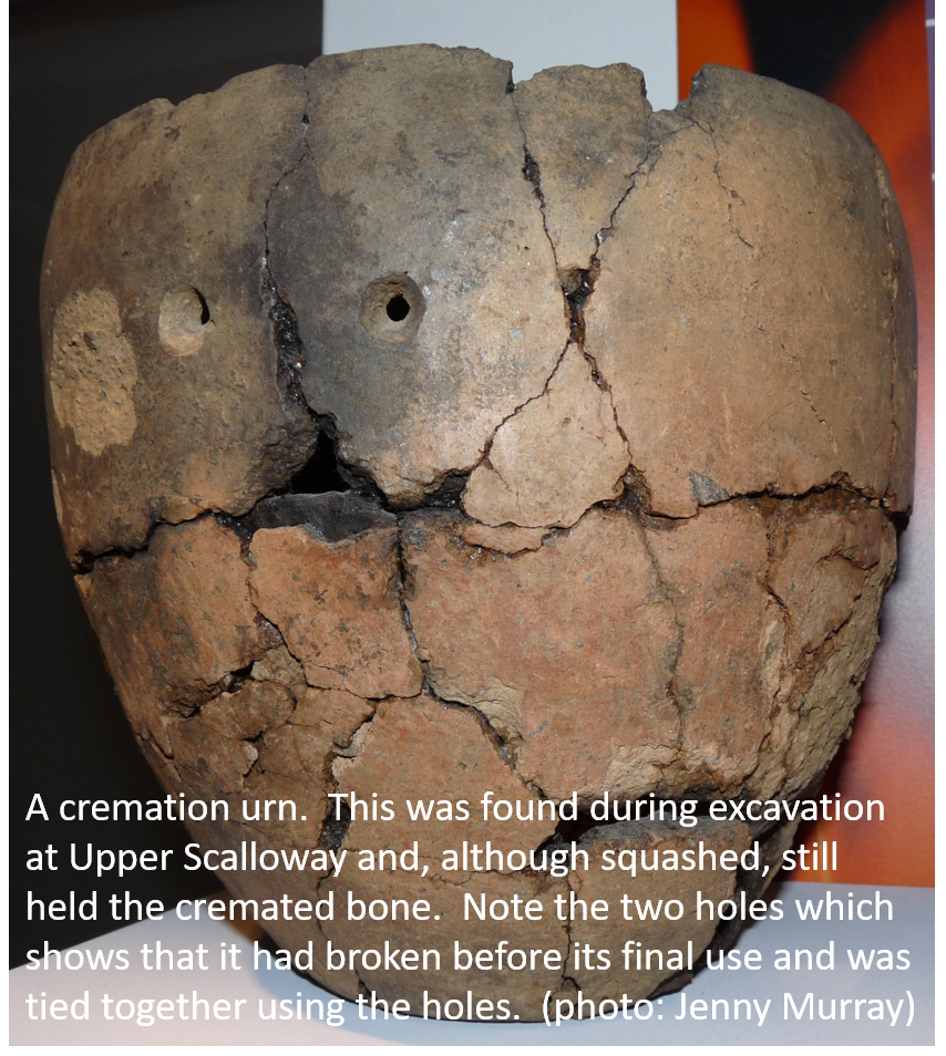 Over the years, early archaeologists debated whether or not these were the remains of Neolithic burial cairns. By the 1980s Noel Fojut had observed their resemblance to Bronze Age cremation cemeteries, occasionally found in the UK mainland. Cremated remains were put into urns and either placed into hollows excavated into the bedrock or set amongst the stones of earlier cairns. The only way of proving whether or not the Rounds of Tivla were cremation cemeteries would be excavation. Even then, past disturbance might have already destroyed the evidence.
Neolithic to Viking Hilltop Graves
The walk to the Rounds of Tivla (HP631 107) is uphill. The road closest to the Rounds of Tivla ends at Gue. The return walk from Gue to the Muckle Heog cairns is about 8km. You could start from the Hagdale end or if you have two vehicles, leave one at either end for a linear walk.
The Rounds of Tivla lie within a boulder-strewn landscape, which makes them harder to spot. They are near the top of Crussa Field.
After visiting the cairns, continue to the northern corner of the field to two Neolithic burial cairns. They have been disturbed many times in the past two centuries, most recently by the fence itself. The cairn survives best to the north of the fence, where there is a very fine cist (a stone box made of thin slabs of stone on end) although older fence lines and a shelter have disturbed it on this side. A third cairn, also disturbed, is located on a rock outcrop to the southwest of the Rounds of Tivla, a little further away.
If you continue east along the ridge for approximately 1.5km, you will encounter another significant group of cairns.
A burial cairn known as Muckle Heog East (HP 630 108) sits on the eastern summit of the ridge. The cairn is 25m across. There are several depressions in the stone covering the cairn, but the chamber is no longer visible. Nineteenth century antiquarians found bones and fragments of a steatite (soapstone) pot inside the cairn.
Muckle Heog West (HP 631 107) lies just below the ridge, about 75m away. This is a classic Neolithic heel-shaped cairn, with some stones visible in its curving front, although it is not possible to identify the chamber. Two cists were set into the boulder spread – four were spotted in 1865 - but these were all later than the cairn itself.
Heading north about 250m, across a field boundary, brings you to a kidney-shaped stony hollow with banks of stone heaped up around it. This is “King Harald’s Grave” (HP 631 111). It has been dug into by antiquarians and is boat-shaped. It is convincing as a Viking grave. Two Viking brooches (now lost) are said to have been found here.
If you plan to make this a linear walk, follow the track which descends from a mast to the road opposite Hagdale. Not far from the mast, on the highest knoll to the north, is a small cairn known as Little Heog (HP 636 109). The slight mound is covered with tumbled stone and today it is difficult to make out the kerb or the central chamber.
Trows and Cairns in Fetlar
Start at the airstrip for a walk to Fetlar’s cremation cemeteries. It is a circular walk which ends at Northdale. It is best left to the winter months due to the bird population, including bonxies. It is an SIC core path and so is provided with gates and stiles. I apologise that following my route will take you widdershins.
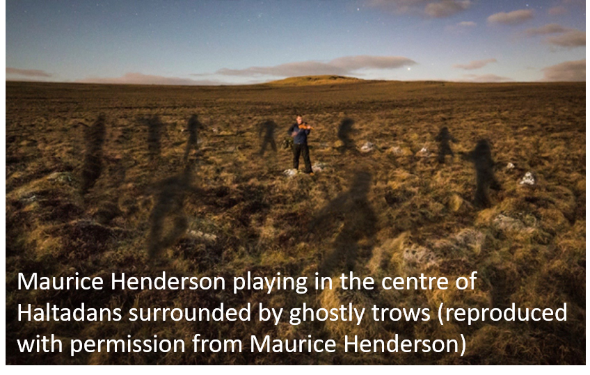 Haltadans (HU 622 924) a little northeast of the end of the airstrip, was described by Jakobsen in 1897 as 'three concentric rings of stones with two higher stones in the middle.’ He added that “Haayltadans” means “lame or limping dance”. The legend runs that a group of trows were so busy dancing around a fiddler and his wife, that they were caught out and turned to stone, not noticing sun-rise. Today the ring of 22 stones, with two central stones and a bank around them, persuades archaeologists that this could be a Bronze Age cremation cemetery.
The Fiddler’s Crus (HU 618 927) about 500m northwest, consists of three rings of small stones set on edge. There are over 50 stones in the largest, although several appear to be missing. Unusually, the concentric bank is inside the stone ring and the central area is flat. The other two circles contain 24 and 5 stones respectively, 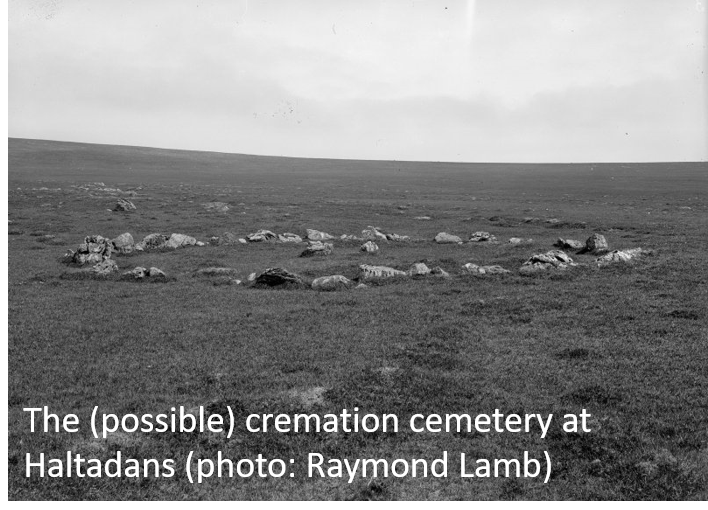 although there are clearly others in place beneath the grass. Each of these could be a cremation cemetery.
The enclosure at Whilsa Pund (HU 618 929) lies a short distance to the north. Inside there are three mounds and the remains of a prehistoric house with several cells or recesses around a central area. There is a second prehistoric house 200 metres west (HU 616 929) of the first. The internal detail survives less well but traces of field walls close by suggest a Neolithic/Bronze Age farm. Both houses are shown as Homesteads on the Ordnance Survey maps.
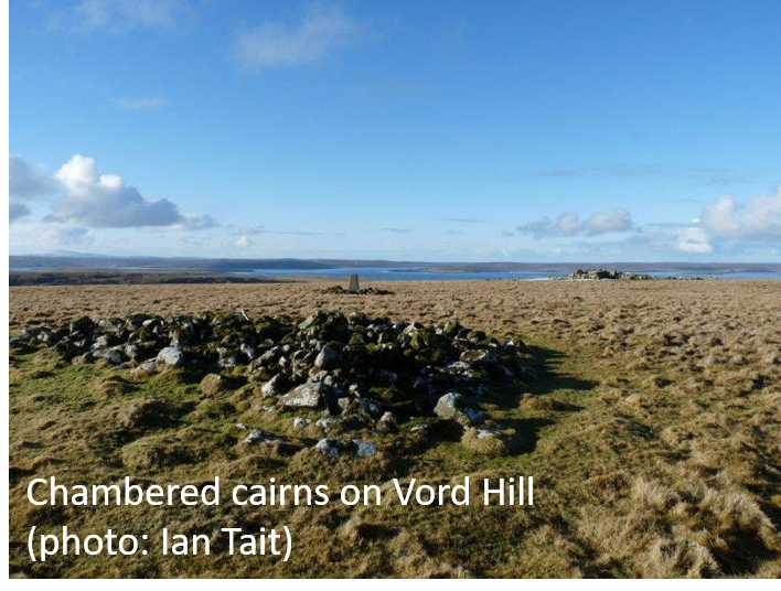 Heading north to the top of Vord Hill there are two chambered cairns, a third cairn, a figure of 8 enclosure and a recent look-out point.
The northern cairn is large by Shetland standards, about 17m long. It has a typical, slightly concave, front and a distinct kerb around its back. There are traces of an inner kerb and also a burial chamber. The southern cairn is smaller but the entrance way and chamber are very clear, although it was disturbed to build the look-out point. The cairn is in the middle of the figure of 8a enclosure, although the enclosure is later than the cairn. The third cairn is at the very highest point on the hilltop, close to the trig point. It shares the distinct heel-shaped plan, but there is no sign of the central chamber.
Returning south for about 1km brings you to the highest point at Stackaberg (HU 613 928), with a prehistoric house at the summit. This is a very unexpected position for a house, and it seems that it was remodelled from an earlier burial cairn.
It is perplexing that these two remarkable landscapes with overtones of death, burial, and ritual, intermixed with houses for the living, are exclusive to the north of Shetland. There could of course be further examples found elsewhere, perhaps concealed by peat, but perhaps Unst and Fetlar had a particular significance. New discoveries and research on these known sites are the only ways we will ever find out.
Dr. Val Turner, Regional Archaeologist, Shetland Amenity Trust
We hope you have enjoyed this blog.  We rely on the generous support of our funders and supporters to continue our work on behalf of Shetland. Everything we do is about caring for Shetland's outstanding natural and cultural heritage on behalf of the community and for future generations. Donations are welcomed and are essential to our work.