
Off the Beaten Track 18 - Eshaness
Published: 31 July 2020
Brochs, Unusual Burials and Arresting Views
Eshaness has spectacular scenery. Its volcanic geology makes it very distinctive. Eshaness also boasts a selection of interesting archaeological sites. This circular walk will take most of your day, but is relatively easy going. (Alternatively, it is possible to do it as three sections and to drive between the key locations.)
There is convenient parking close to Eshaness Lighthouse (HU 206 785). The lighthouse was built in 1929 by David and Charles Stevenson, 100 years after their ancestor, Robert Stevenson, built Sumburgh Head in 1821. Eshaness has a short, square tower with lower accommodation on the landward side.
Set off west from the car-park, around the dramatic Calder Geo, before heading north to the Loch of Houlland (HU 214 792). Cross the dyke just beyond two small lochs using a ladder-stile close to the coast.
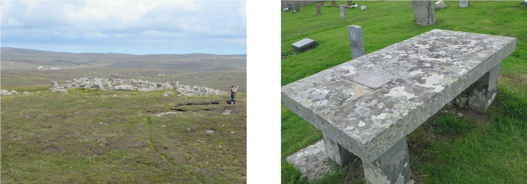
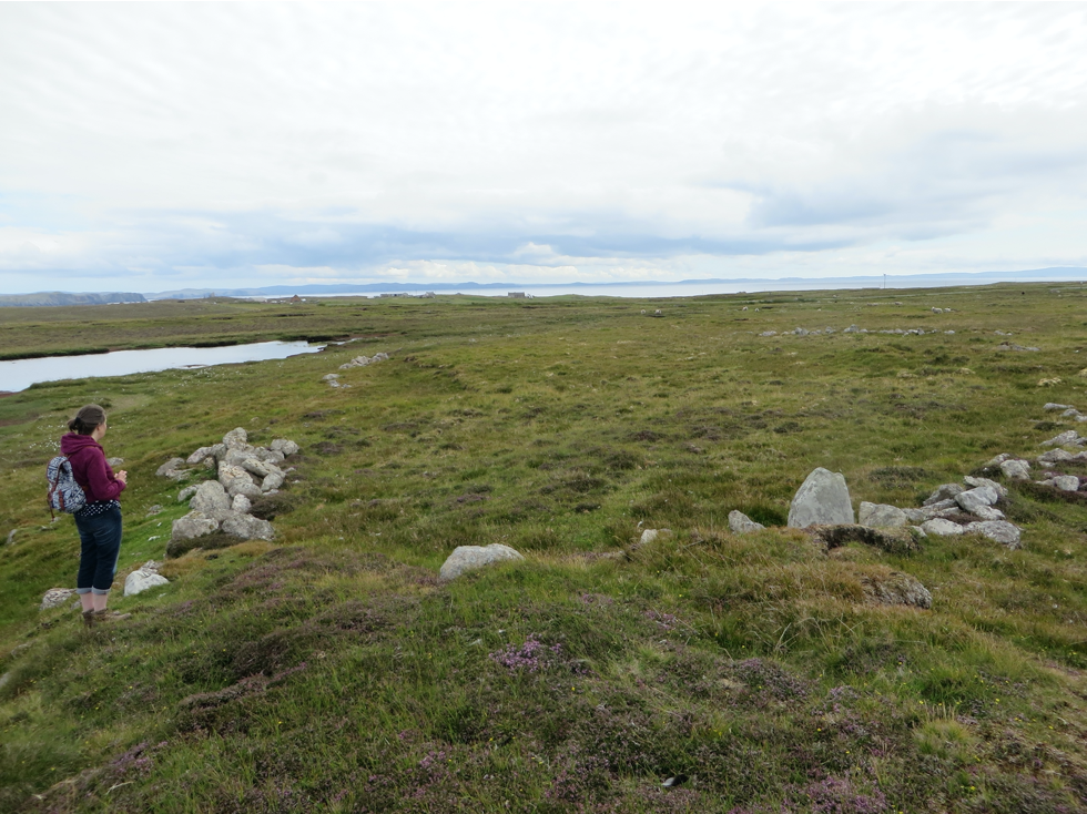
In contrast with the majority of brochs which are close to the coastal edge, the Broch of Houlland sits 400 – 500 metres inland, on an islet at the edge of a loch. It is attached to the shore by a causeway – with some similarities to Clickhimin. There is a wide stone rampart across the access from the shore. Houlland has not been excavated and is full of tumbled stone from the walls. It stands about 3.5 metres high and the entrance, on the south-west side, had a guard cell in the wall on the right. You might spot two other ruined cells within the walls.
The islet continued to be used after the broch ceased functioning as a broch, since there are several oval and sub-rectangular foundations nestling around it on the promontory. The builders of these later structures probably reused stone from the upper section of the original wall and were perhaps Picts. It may have been in that later period that two additional dykes were built across the neck of the causeway.
While you are in the area, it is only a short step further to the hair-raising holes of Scrada. The roof of a deep cavern has collapsed and the noise of the sea crashing in resonates eerily around it. There are several horizontal mills (HU 213 793) on the burn which flows into it.
Continue round the loch, past the house of Priesthoulland (HU 216 794), picking up the track which leads to the gate. Unfortunately the gate was padlocked last week, which meant that I had to climb over the fence. From the gate you can see stones surrounded by a patch of green, a short distance up the hill. Burial cists, most usually Iron Age, are stone lined boxes in which people’s bodies were laid - usually on their side, with their knees drawn up to their chests. This cist (approximately HU 219 790) is made of the local chunky stone and is more blocky than cists normally are. There is a stone in the middle which has probably tumbled in from the side, rather than being intended as a pillow.

Head up the hill across two ridges and on the summit of the second you will find a curious large, square, Neolithic chambered cairn (HU 222 789). If you go too far south, you will meet a fence. In that case, follow it uphill and you will find the cairn not far from the corner.
Square cairns are unusual in Shetland. Like the cist, it has huge stones around the edge and it is possible to spot at least two sides of the central chamber, which is remarkably small compared with its overall size. There is a wonderful view of Dore Holm from here with a smaller stack in front of it lined up exactly with the opening and, on a clear day, there are glimpses of Foula beyond.
There is a second, much smaller, square cairn at the head of Muckla Water (HU 422 790). To find it, head north-east. It is a similar distance from the loch but on much lower ground.
From this cairn aim for the road, passing between Muckla Water and Black Water. Your path will take you over a prehistoric house and associated well-preserved fields, including a large irregular enclosure (HU 227 787). The field divisions remain as an extensive series of fragmentary low walls partly buried in shallow peat.
When you reach the road, turn left to find two prehistoric houses (HU 229 786) - or a house and outbuilding - on the left-hand side of the road and further stonework on the right. The main house survives as an oval built of the local large boulders. Both the inner and outer wall faces are visible, suggesting a wall thickness of up to 2 metres. It would seem that the road went right through this settlement. Historic Environment Scotland saw this as being part of the same field system which you have already passed through.
Turn back along the road and take the turning on the right, which leads towards the lighthouse. Then, however, branch off on the track to the ruins of the 14th century Cross Kirk (HU 212 780). The church itself has been filled in with earth but there are some intriguing grave slabs to find.
One bears a surprising inscription. It is the grave of Donald Robertson who died in June 1848, aged 63. The stone tells us “He was a peaceable, quiet man and to all appearance a sincere Christian. His was death was much regretted which was caused by the stupidity of Lawrence Tulloch of Clothister [Sullom] who sold him nitre instead of Epsom salts by which he was killed in the space of 5 hours after taking a dose of it”.
One stone with a runic inscription has also been found here. It is thought to be a 14th century grave slab and has defaced runes around the edge. It was described by George Low in 1774. Today it lies beneath a modern memorial to Johnnie Notions (John Williamson). He was a self-taught physician, with little formal education and no training, but he developed and administered a vaccine for small pox in the late 18th century. He is said to have immunised 3000 people and never to have lost a patient. His house is now the camping böd at Tangwick.
Next, climb the hill beside the graveyard to reach Sae Brek broch (HU 4210 780). The broch was partially excavated by Charles Calder around 1950. Its outer face is clear in places, but there is tumble and grass at other points. The bank surrounding the broch hides a substantial wall. Surprisingly, it appears to be pear-shaped rather than circular. There is such an expansive view from this high spot that it has been reused for both an Ordnance Survey trig point and a coastguard look-out. The top of the broch was partly flattened and three buildings were built as part of the look-out, one of which is hexagonal. Until recently, trig points were essential for map making – as well as for accurate archaeological survey.
The lighthouse and carpark are in clear view from the broch and so, keeping south of the Loch of Framgord, finish your walk where you began.
Dr Val Turner, Regional Archaeologist, July 2020
We hope you have enjoyed this blog.  We rely on the generous support of our funders and supporters to continue our work on behalf of Shetland. Everything we do is about caring for Shetland's outstanding natural and cultural heritage on behalf of the community and for future generations. Donations are welcomed and are essential to our work.