
Off the Beaten Track 11 - In search of Brochs
Published: 12 June 2020
Brochs are the best known of Shetland’s prehistoric remains and Mousa is regarded as iconic throughout Scotland. In spite of their popularity, brochs are still shrouded in mystery. Archaeologists discovered that Old Scatness was built between 400-200 BC, earlier than previously thought. Brian Smith has observed that brochs were placed carefully, enabling people to see from one to another, which implies that they are all broadly contemporary. It would have been possible to send a basic message along the chain.
Archaeological opinion varies over the question of why they were built. At one end of the spectrum brochs are interpreted as the equivalent of Laird’s houses, impressive and prestigious places, which may have stored surplus food and goods. At the other end, brochs are seen as defensive, or perhaps building them was an aggressive act. The truth may well lie somewhere in between.
Brochs are always roughly circular, with external walls about 5 metres thick, surrounding an internal area between 6 and 10 metres in diameter. Above ground floor level the wall is double-skinned, tied together with flat stones and usually having an internal staircase between them. Whether all brochs were originally as tall as Mousa, or were roofed, are debates which are harder to resolve.
Many brochs are partially or completely surrounded by impressive sequences of banks and ditches. Some, such as Mousa or Clevigarth, are at the edge of the coast whilst others, like Underhoull, are above a scarp. Others, such as Mail, Cunningsburgh or Coppister, Yell, are on offshore stacks. Still others, including Houlland, Eshaness, and Clickhimin, are found on islets in lochs.
Today’s two walks take in some impressive brochs which visitors to Shetland generally miss: Culswick on the West Side and Burraness Yell. (There are several brochs which include the place name “burra”, a variant of “broch”, meaning “fort” or “strong place” in Old Norse.)
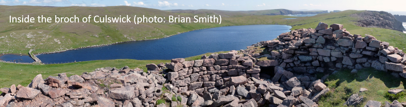
Culswick
The walk starts along a track, leaving the road into Culswick about 300 metres before the road ends. The track leads to a Methodist chapel built in 1893, but it forks just before you get there. Take the southern (left) peat track and pass Sand Loch. The ruined buildings, small plantiecrubs (enclosures for growing kale) and larger kale-yards are part of a once busy crofting landscape. That may explain why there is a chapel in a now secluded spot.
The abandoned croft building at the south end of the Loch of Sotersta includes a curious feature – a tall (1.6m), chunky, standing stone built into the gable wall (HU 262 446). John Stewart suggested that there were two other standing stones close by. One is a boulder, but the other could be a standing stone.
A burn flows south from the Loch, flanked by two burnt mounds. The eastern one is around 50 metres south of the croft building. It is about 8 metres long and nearly a metre high. Small fire-reddened stones peek through the vegetation. The eastern mound (HU 261 446) is slightly harder to spot.
At this point you have a choice. Either rejoin the track and head north and west, crossing the Loch of the Brough via a causeway near the north end, or continue east, over rough ground, round the south end of the loch. The unexcavated broch (HU 254 448) stands close to the cliffs, with a good view over the sea. There is a deserted croft in front of it.
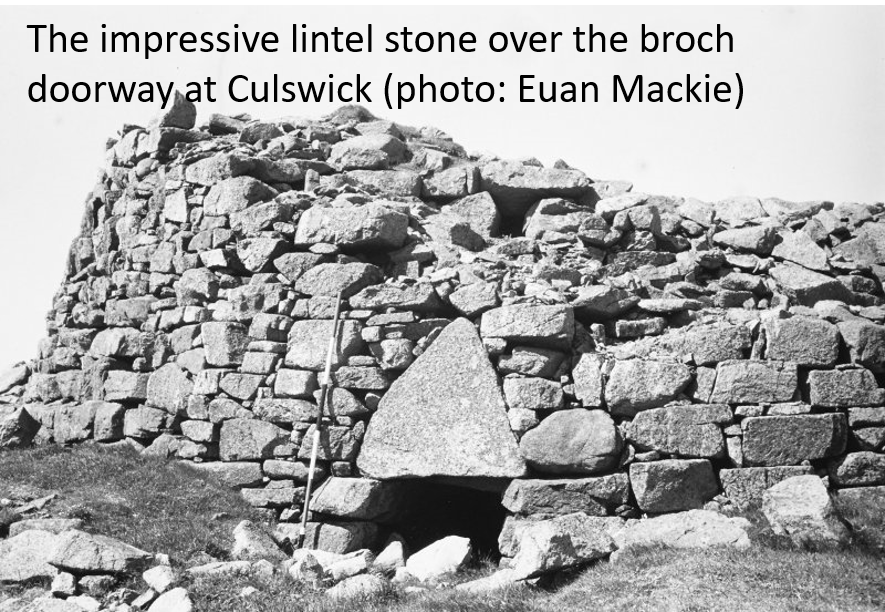 In 1774 George Low recorded the broch as standing 23 feet (7 metres) high. His drawing shows three galleries between the walls. Today the broch stands only to the top of the first floor gallery, around 4 metres high. It is built of the local red granite, a far more difficult task than building with the Mousa flagstone. It has an impressive triangular lintel above the entrance. Whilst this may have been a structural feature, to relieve the load from the roof of the passage, there is a triangular stone above the entrance to Old Scatness broch which was more ornamental than functional. If the Culswick lintel was intended to impress, it succeeds today.
Inside, the broch is full of debris. Instead of the usual scarcement (ledge), which archaeologists believe supported wooden structures, a series of blocks project at intervals about 3 metres above floor level. There are door-checks about 2 metres along the passage and a tall “guard cell” to the right. Outside, it is possible to see the surrounding defences most of the way round.
You can either return the way you came (a walk of about 4km), or you can follow the coast south and east, passing Burri Stacks. The southern stack (HU 261 441) has seven small buildings on top, a possible Pictish monastic settlement.
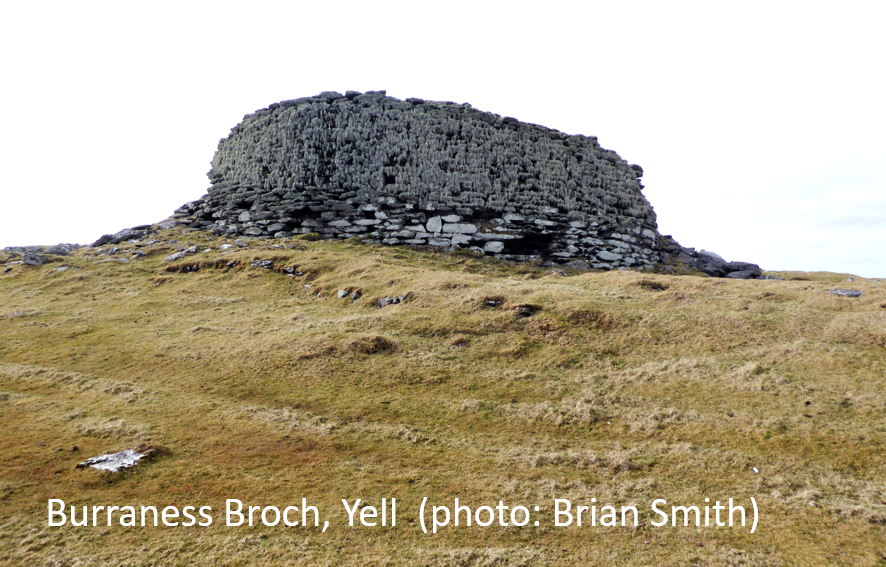
Burraness, Yell
 Travelling south from Gutcher, turn right (south) on the road to North Sandwick, passing a 1.5 metre high standing stone on the left (HU 548 987). To see it more clearly, walk back along the shore about 400 metres from North Sandwick, and then turn inland.
It is usually an out and back walk (about 4km) to the broch, but if you have a second car you could park at Kirkabister. Begin by heading south to the bay following the coast, staying above the low cliffs. Continue south, passing the Haa of Sandwick, until you reach the broch at the far end of Burra Ness (HU 557 957) on a slight rise overlooking the sea. It survives to about 3 metres on the seaward side. The south and west sides survive less well, making it possible to see a “cell” built into the wall thickness on the southeast side, but there are no traces of the entrance.
The broch stands on a low artificial platform, built onto and into by later structures, which survive as low, grass-covered, banks. The remains of surrounding earth ramparts survive south of the broch. There are traces of outbuildings towards the north, south, and south-east, and slight indications of surrounding ramparts.
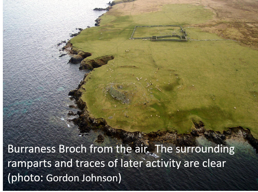 A little to the south is a now abandoned croft. Low referred to a field of corn growing here in 1774. West of the broch there are several cairns of field-cleared stones, which may have been Iron Age or part of the crofting settlement.
A heel-shaped burial cairn survives on the southwest side of the Ness (HU 553 953). It shows up well because it is greener than the surrounding vegetation. The heel-shaped front (façade) is picked out with large stones. It measures about 8.5 metres across the façade, and is just over 7 metres deep, although the footprint is confused by tumble. Immediately to the southwest you can find the foundations of a modern rectangular structure.
From this point either head back north, or follow the fence-line west for just over 1km to Kirkabister (HU 540 956). The farmhouse is now falling down, but it includes one of Shetland’s four pony punds, situated between the house and a cottage. It had four stable blocks set round a courtyard.
A little further north, beside the track (HU 539 956), the compilers of the 1878 Ordnance Survey maps recorded a chapel in their “Name Book”. Human remains were found here.
There is evidence for around 120 brochs. Sometimes the only clue is a place name. Five previously unsuspected brochs have come to light since I came to Shetland – so you could even find a “new” one.
Dr. Val Turner, Regional Archaeologist, Shetland Amenity Trust
We hope you have enjoyed this blog.  We rely on the generous support of our funders and supporters to continue our work on behalf of Shetland. Everything we do is about caring for Shetland's outstanding natural and cultural heritage on behalf of the community and for future generations. Donations are welcomed and are essential to our work.